Kirk Lapham
Department of Geology
The College of Wooster
Disclaimer: This material is based upon work supported by the National Science Foundation under Grant No. 9910805. Any opinions, findings, and conclusions or recommendations expressed in this material are those of the author and do not necessarily reflect the views of the National Science Foundation.
<– Return to main pages list

During the summer of 2000, I was able to travel to Alaska with the support of a National Science Foundation Research Experience for Undergraduates (REU) grant. While in Alaska I conducted research for my Independent Study at The College of Wooster. I traveled with four others, my advisor from The College of Wooster Geology Department, Dr. Greg Wiles, Dr. Parker E. Calkin of the University of Colorado in Boulder, Austin Post of the United States Geological Survey, and a fellow College of Wooster student, Aaron Shear (Figure 1).
We spent two weeks collecting data at the Columbia Glacier near Valdez, Alaska. The Columbia Glacier is one of the largest tidewater glaciers in the world and has been the subject of intense study for many years. The Columbia Glacier has been retreating into the Chugach Mountains for decades at a catastrophic rate (Figure 2).
This retreat leaves the Columbia Bay choked by icebergs of all sizes (Figure 3). As this retreat continues, trees killed by the glacier during past advances are unearthed. These trees were the subject of our trip to Alaska. The group spent the two weeks collected samples from these trees in an effort to describe the conditions surrounding the movement of the Columbia Glacier (Figure 4).


Many of the trees found in the area were partially buried, with roots in place. This ensures that the trees were killed where they were found. Secondly, many of the trees were found at any angle pointing down the Columbia Bay, away from the glacier (Figure 5). This provides evidence that the trees were over by the Columbia Glacier as it advanced down the fjord.

Using dendrochronology, I developed a thousand year tree-ring chronology from Columbia Glacier. Dendrochronology is a method of comparing tree rings from a group of trees in an effort to crossdate them and create a calendar date for their death. This provided the exact time when the Columbia Glacier advanced through an area of the Columbia Bay. Comparing this information to similar information collected for other glaciers in the area provided insights to the advance rates of calving glacier and contribute to the description of climate over the late Holocene.
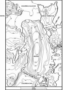
Using sites throughout the Columbia Fjord (Figure 6), the Columbia Glacier tree-ring chronology was created. This preliminary chronology shows four distinct pulses of advance between AD 1057 and 1778 (Figure 7) during a maintained advance during this time with possible stabilization or minor retreat. Comparing these pulses of advance with those from surrounding land terminating glaciers within the Gulf of Alaska, it is clear that the Columbia Glacier has moved out of phase with land terminating glaciers. Possible causes of the asynchronous advance may include fjord geometry and water depth within the fjord. These aspects also play an important role in the ongoing retreat today. The initial retreat from the terminal moraine shoal may have been induced by climate change, however, the retreat has been maintained due to the large increase in the water depth behind the terminal moraine shoal.


Related Links
The Tree Ring Lab of Lamont-Doherty Earth Observatory had information about many other dendrochronology research projects.
The Glacier Dynamics Group at the Byrd Polar Research Center, Ohio State University has excellent information about glaciers in general as well as the research they are currently working on.
This article co-written by Austin Post, who joined us on this research trip, discusses his work with the Iceberg Monitoring Project.
Related pages
- Dendroclimatology of the Columbia Bay Region, Prince William Sound, Alaska by Aaron Shear
- Late Holocene Glacial Stratigraphy of Columbia Bay Alaska: Extending the Record by Matthew Beckwith-Laube
- Columbia Glacier 2001 by Clinton Bailey
- Calving Glaciers with an Emphasis on Columbia Glacier, Prince William Sound by Megan Kennedy
